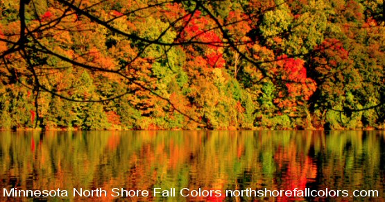
Fall Colors North Shore Minnesota
Fall Color Tours
Fall Color Reports
Bird Migration
Birding HotSpots
On the Minnesota
 North Shore

Hiking, biking, birding, driving, sailing, paddling and more in our Activity Guide

North Shore Fall Color Tours
 Minnesota North Shore Fall Colors

Home | Current Reports | Lodging | Dining | State Parks | Maps
North Shore Attractions | Canoe Trips | Things To Do | Books | Weather | Winter Fun

North Shore Fall Color Tours
w w w . n o r t h s h o r e f a l l c o l o r s . c o m

Green
Pines, cedar, spruce, balsam
Trees Changing
Tamarack
Peaking Fall Colors

North Shore Fall Color Progress Indicator

Fall Color and Bird Migration Report
[  p u b l i s h e d   a b o u t   e v e r y d a y  ]

North Shore Fall Colors 2011! Fewer people, cooler temps and things you don't see in the cities like bald eagles and wolves.

>>Report for October 18, 2011

Fall Color Status:  Maples, aspens, poplars and oaks have peaked and have fallen to the ground. Generally colors are best for maple and oak from mid September into early October. Colors for birch and poplar/aspen are last two weeks of September into mid October. Tamarack changes to lemon yellow at the end of October into November. We report fall colors into two areas; the lower North Shore and upper North Shore.

FALL COLOR REPORT FOR LOWER NORTH SHORE / DULUTH AREA / HWY 61 MILE 0 TO MILE 70>>>Duluth through Little Marais, which includes Tettegouche State Park, St. Louis and Lake Counties. Current Report October 18; maples, aspens, poplars, oaks have peaked and have fallen to the ground. Tamarack is beginning to turn yellow. Awesome time of year to hike North Shore trails and explore the area, now that the leaves have fallen.

FALL COLOR REPORT FOR UPPER NORTH SHORE HWY 61 MILE 70 TO USA / CANADA BORDER >>>All of Cook County from Schroeder up through Grand Portage, Gunflint Trail and the Canadian border area. Current Report October 18; maples, aspens and poplars have peaked and have fallen to the ground. Tamarack is beginning to turn yellow. Awesome time of year to hike North Shore trails and explore the area, now that the leaves have fallen. Great number of bald eagles and falcons have been migrating overhead.

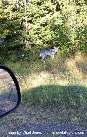
Great opportunities exist for wolf, deer, and red fox watching at night. Also bald eagles and ravens can be seen on road kill along Hwy 61 during the day. At mile 115 three weeks ago; 2 wolves and a red fox have been consuming a deer. At mile 121 two weeks ago; at least one wolf and a red fox have also been consuming a deer. During daylight; ravens and bald eagles are feasting together. Saturday night 11pm September 24th in downtown Grand Marais two wolves trotted down Hwy 61 and turned down into RV Park, and ran into pond area by municipal pool.

Timber Wolf along Hwy 61 Grand Marais, Minnesota

Another wolf October 3rd in broad daylight eating a carcass at mile 116.5 Hwy 61 [see image to left]. Another wolf has been seen past two weeks at night and during the day around Hwy 61 mile markers 114 to 118. This wolf has an injured rear leg and is working residential areas, searching for an easy meal, most likely a family pet. Wolf sightings are on a sharp increase due to over population and lack of fear for humans. We sat and watched this wolf for ten minutes, rolling and chewing on a dead animal. Areas east of Grand Marais to the Brule River have been the hot spot the past three weeks; between 9pm and midnight we've sighted 8 wolves, 17 red fox and 56 deer on Hwy 61 between Grand Marais and Judge Magney State Park.

Wolves are commonly seen on and along Hwy 61 in Cook County in the; Lutsen area, Cascade River State Park area, up and through downtown Grand Marais, Colvill, Kadunce River Wayside area, Judge Magney State Park and Hovland.

2008 and 2009 - very late fall colors ended rather abruptly Oct 15th and 17th as strong fall squalls rolled in. Watching these storms rip leaves off trees and spin up Lake Superior into huge shore pounding waves, is a spectacular scene.

>>Keep these things in mind;

Watch out for ticks... we've been finding very small deer ticks on dogs and people. Hard to believe but, deer ticks are very active during the warm fall days and often attach in the very private body areas. Deer ticks are a recent invasive species that has moved into North Shore areas, possibly from excessive deer populations. (might be a good place to find an area to deer hunt.)

Please be courteous to those that don't want to drive as slow as you. Turn-out in a safe location and let faster traffic pass. Not everyone is leaf looking. People live and work here too. Thank you!

2011 Report Archives

fall_colors_09012011 | fall_colors_09042011 | fall_colors_09062011 | fall_colors_09072011
fall_colors_09082011 | fall_colors_09112011 | fall_colors_09142011
| fall_colors_09162011
fall_colors_09172011 | fall_colors_09192011 | fall_colors_09212011 | fall_colors_09262011
fall_colors_09302011 | fall_colors_10032011 | fall_colors_10082011 | fall_colors_10102011
fall_colors_10132011 | fall_colors_10142011

See fall color images of Oberg Mountain from September 30th, 2010.

See fall color images of Cascade River from September 30th, 2010.

SPECIAL EVENT>>Split Rock Lighthouse State Park Beacon lighting and anniversary of the sinking of the Edmund Fitzgerald Nov 10th. read more about this event...

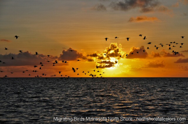
Birds Heading South: A west or north wind, or combination of, are the best winds for experiencing migration. Birds get stacked up along Lake Superior as the wind pushes them towards the Big Lake. Easier to spot species are; bald eagles, red-tailed hawks, are moving through the area. Over 12,000 broad-wings passed over Hawk Ridge September 15th, 2011.

Birds migrating along Lake Superior

Observers hit popular locations and the shoreline to enjoy the lakeshore and passing birds. Find out why birds get funneled along Lake Superior. Or find good birding spots.

Many types of birds migrate through the Minnesota North Shore, particularly large number of raptors. These 'birds of prey' include; eagles, osprey, falcons, turkey vultures, owls, hawks and accipiters. Shore birds and waterfowl also move through the corridor along Lake Superior. Peak time for migration is mid September to early October.

 Grand Marais Cloud Formations

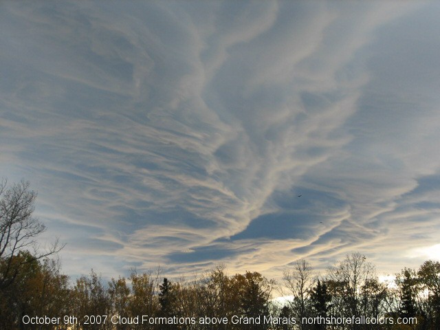
>>>MORE ABOUT WINDS AND MIGRATING BIRDS... Image above was taken at 5pm Oct 9th, 2007 overlooking Grand Marais from the east.
Notice turkey vultures near center right. Migrating birds were using the east winds to their advantage and the crazy cloud formations made a great backdrop.
Migrating birds are numerous along the whole North Shore, with large numbers of birds concentrated along the shorelines when the winds are out of the north, west or combination of. Reluctant to cross the Big Lake, migrating birds become funneled along the shoreline and the hills along Lake Superior. Best areas for spotting migrating birds is within 1-2 miles of the shoreline of Lake Superior when these conditions exist.

Don't miss stopping at Hawk Ridge on your way up or down. Read more about Hawk Ridge and other great places to view migrating birds below...

Minnesota North Shore Map

>>>Duluth - Hawk Ridge | Grand Marais area | Scenic Hwy 1 toward Ely | Current bird migration report

In Duluth, Minnesota at Hawk Ridge Nature Preserve

>>>We think Hawk Ridge is the best spot for viewing migrating birds in the Midwest! The combination of fall colors, birds migrating over and the great view of the Duluth Harbor is fantastic!

BROAD-WINGED HAWKS in record numbers at Hawk Ridge!  Often 1000s are counted in a single day in September. Hawk Ridge is a nature preserve dedicated to birding, and is one of the best places in the mid-west to see migrating birds, especially raptors. "Raptors" are birds of prey, such as bald eagles and red-tailed hawks. Check out the Hawk Ridge Web site for Public Programs, directions and a map.

One of the more spectacular migration events is the kettles of broad-winged hawks seen from Hawk Ridge above Duluth, Minnesota. During the fall these football sized raptors/birds of prey are in large numbers called "kettles." From approx. August 25th - September 30th the BWHs gather together and form what looks like a moving tornado.

Over 50,000 migrating birds pass over Hawk Ridge each year during the fall migration. Check out the Hawk Ridge Web site for Public Programs, directions and a map.  A great place to stop and experience a very unique event, take a break from driving! Nice place to see fall colors, click here for more details and directions. Events and bird counts, directions and more.

Request lodging information at: www.northshoreinfo.com/lodging or check out the dining opportunities.

----------------------------------------------------

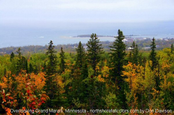
Overlooking Lake Superior and Grand Marais, Minnesota

Overlooking Grand Marais Minnesota

These are great places too!!

There are two other, less known places to view the migration, the first one is 2 miles up the Gunflint Trail/County Road 12 out of Grand Marais. The Pincushion Mountain Recreation Area is a right-hand turn onto County Road 53. It has a large parking area and is a paved road, off of the Gunflint Trail/County Road 12. Nice place with trails for Mtn. biking and hiking. The second one is just west of Pincushion along the same bluff overlooking Grand Marais, the Old Ski Hill Area/Sawtooth Bluff. Turn west/left onto County Road 64, about 2 1/2 miles from Grand Marais or less than a 1/2 mile after the Pincushion Mountain Recreation Area turn. Once you're on County Road 64 it is about 2 miles all the way to the end, where there is a great view of Grand Marais and Lake Superior. You'll see numerous communication towers near the parking areas.

Request lodging information at: www.northshoreinfo.com/lodging or check out the dining opportunities.

----------------------------------------------------

Along scenic Hwy 1 toward Ely, Minnesota

Another great place for birding all season long!

The Birch Lake Dam
The Birch Lake Dam is located on the South Kawishiwi River, which is the west border of River Point Resort & Outfitting Co’s mile long private peninsula on scenic highway #1, which connects the North Shore to the Ely area. The dam is a hop, skip and a jump from River Point by either boat (1 mile) or by foot or vehicle (1.5 miles). This is Ely area ornithologist, Bill Tefft's all time favorite location for birding—and Bill has birded across the region for more than 25 years. The area which was first mentioned in one of the oldest guides to birding in Minnesota, has been a hot spot for literally decades. Tefft says it is still one of the most dependable birding spots in the area. Lots of morning sun attracts the warblers, flycatchers and other birds. Water is right there, so waterfowl can be counted on. You can even walk along the dike that extends on either side of the dam for a better look at the surrounding treetops. Adjacent is a gravel road which is also a birder's fun spot to check out. River Point Resort & Outfitting Co.

Request lodging information at: www.northshoreinfo.com/lodging or check out the dining opportunities.

----------------------------------------------------

North Shore Fall Colors 2011!

Request lodging information at: www.northshoreinfo.com/lodging or check out the dining opportunities.

Take your pick of over 25 North Shore Fall Color Tours™ from northshorefallcolors.com. Try one of these routes for wildlife viewing, hiking, biking, driving, canoeing or sailing on the North Shore!  Use caution some road and trails are not for all/any vehicles. Daily Fall Colors Report | Why do leaves change color?

Special topics:  

Why do leaves change color | Weather for the Minnesota North Shore

North Shore Lodging Specials | North Shore Fall Color Tours™ from northshorefallcolors.com Try one of these routes while your hiking, biking, driving, or sailing on the North Shore!

Autumn on Minnesota's North Shore of Lake Superior will leave you with incredible impressions.

North Shore Fall Colors
© 2011 Scott Benson
Why Do Leaves Change Color?

Leaves change color due to shifting rhythm of the day and night. The long warm days of summer eventually turn shorter and cooler, which triggers a chemical clock inside the deciduous tree to enter winter sleep or dormancy. Deciduous means "a tree with leaves instead of needles." 

During the summer months the color or "pigment" of leaves are mostly green from the chlorophyll which the tree is abundantly producing. But as fall approaches the tree enters dormancy and stops producing food and chlorophyll. As the amount of chlorophyll diminishes, a group of pigments called carotenoids start to show. Carotenoids are the yellow, brown and orange colors we see during fall.

Deciduous trees on the North Shore are mainly; sugar maple, aspen [aka poplars], paper birch, ash, silver maple, tamarack ( a deciduous coniferous tree ) and some black cherry and oaks. Trees with needles are called conifers, on the North Shore conifers are mainly; balsam fir, white spruce, white pine, red pine, jack pine, and white cedar. The tamarack appears to be a species of evergreen during the growing season, but, in fact, is deciduous, making a late-season color change to lemon yellow and dropping it's needle looking leaves as the snow begins to fly in November.

Autumn is the best time for being out-of-doors. The bugs have pretty much died off and the days are still warm, and the nights are cool, great for hiking, paddling, biking, birding, sailing or driving the North Shore of Lake Superior.

  Listed below are over 25 suggested fall color tours, detailed for hiking, biking, driving or sailing!

North Shore Fall Color Tours™
Fall Colors

Lower North Shore Fall Color Routes

Fall Colors
NorthShoreInfo.com Top Pick - Ultimate Fall Colors - Hiking/Biking/Driving/Birding

The Skyline Parkway/Hawk Ridge Tour - Hiking/Biking/Driving/Birding <<Best for All Fall

A must visit to say you have truly explored Duluth. Skyline Parkway overlooks the city of Duluth, the Duluth Harbor and Lake Superior. Great views of fall colors and incredible bird migrations!

From I35 take exit 249 and drive east. Follow signs labeled "Skyline Parkway." Hawk Ridge is one area this routes passes through.

Direct route to Hawk Ridge: From Downtown Duluth, drive northeast on Superior Street to 43rd Ave. Go left from Superior Street onto 43rd Ave and drive to Glenwood Street. Turn left onto Glenwood Street. Drive on Glenwood to the top of the first hill to Skyline Drive. Turn right onto Skyline and go about 1 mile (about half a mile beyond the end of the pavement) to the Main Overlook.

As an alternate route from Interstate 35, you can drive north on I-35 to the 26th Ave / London Road exit. Go right on London Road, which is also Highway 61 here. Turn left onto 43rd Ave and follow the remaining directions from above.

Best all fall. Duluth Area: Lodging

North Shore Fall Color Tours™ are Sponsored by the following North Shore lodging establishments.
North Shore Cove Point Lodge
Cove Point Lodge

Beaver Bay, Minnesota
River Point Resort & Outfitting Co
River Point Resort & Outfitting Co.
Ely, Minnesota
Lutsen Resort
Lutsen Resort

Lutsen, Minnesota
Fall Colors The Two Harbors to Beaver Bay Tour - Driving <<Best for Late Fall
30 miles + 24 miles return to Two Harbors
From Hwy 61 in Two Harbors, Minnesota, drive north on Co. Rd. 3 for 28 miles to the Lax Lake Rd (Co. Rd. 4), then south on Co. Rd. 4 for 2 miles to Beaver Bay. This route uses Hwy 61 as a third, returning route. To continue on, see the Beaver Bay to Illgen City Drive below. Best for late fall. Also nearby is Gooseberry State Park. Two Harbors: Lodging  Dining  Shopping
Fall Colors The Split Rock River Loop Tour - Hiking <<Best for Late Fall
On Hwy 61 about 15 miles north of Two Harbors, park on the west side of the river. The upstream portion of this trail sits about 60 feet above the river along a rocky ledge. On the downstream, you'll experience overlooks of the river valley, as you head inland, you can look out to the Big Lake Superior. Best during the late fall season. Also nearby is Split Rock Light house State Park and Tettegouche State Park. Beaver Bay: Lodging  Dining  Shopping or Two Harbors: Lodging  Dining  Shopping
Fall Colors The Superior Hiking Trail from Castle Danger to Gooseberry Falls Tour - Hiking <<Best for Late Fall
From Hwy 61 just past mile marker 36, in Castle Danger, Minnesota drive north on Co. Rd. 106 (which turns into Silver Creek 617) to parking on right 8 1/2-mile hike. You may consider leaving a car at Gooseberry Falls for this 8 1/2-mile hike. The trail runs north of Castle Danger to Gooseberry Falls State Park. Trail highlights include overlooks at Wolf Rock, Crow Creek Valley and Mike's Rock. The upper reach area of the Gooseberry River is really gorgeous. The round trip hike to the Crow Creek Overlook and back is 2 1/2 miles. Best for late fall. Gooseberry Falls Area: Lodging  Dining  Shopping
Fall Colors The Gooseberry Fifth Falls Trail Tour - Hiking <<Best for Late Fall
From Hwy 61 head south into the Gooseberry Falls State Park visitor center. You'll end up at the east bank of the Gooseberry River. This 1 1/2 mile loop passes the upper Falls as it leads to the Fifth Falls. Very enjoyable autumn stroll with great vistas. Best during the late fall season.  Gooseberry Falls Area: Lodging  Dining  Shopping
Fall Colors Silver Bay to Birch Lake Dam/Ely Tour via Scenic Hwy 1 Driving/Wildlife/Birding/Fishing<<Best in September, Great throughout Spring and Summer
The Silver Bay stretch of approximately 55 miles, or a driving time of 1.5 hours, to the Birch Lake Dam on scenic Highway 1, which is a two lane paved highway, runs through some of the most beautiful terrain in the state, and is a twisty and undulating drive. It will surely delight your senses. Some new sections of the highway make the trip even more enjoyable. This meandering road follows most of the original path of the early loggers to northeastern Minnesota. Early autumn color can appear along the roadway as soon as late August, with the highway being a blaze of color in weeks two-four in September. The brilliant yellows of birch and aspen / poplar are highlighted by the gorgeous reds, oranges, and melon colors of the many maples. The last 8.5 miles from the Birch Lake Dam to Ely are equally beautiful in autumn.

Opportunity abounds to view the mighty Minnesota moose along the many marshy areas on either side of Highway 1, as well as deer and even beaver and eagles, especially from Isabella to Ely. Other highlights are a stop at the scenic Stony River wayside rest where the river bubbles up next to the highway and the South Kawishiwi (Half Way) Bridge which offers great photo opportunities viewing north toward the Boundary Waters and south toward picturesque Birch Lake.

River Point Resort & Outfitting Co. is bordered on the east by the South Kawishiwi River and on the west by the Birch Lake Dam, with Birch Lake lying to the south of its private peninsula. You can be outfitted by River Point for a Boundary Waters canoe trip for the day or for several nights, rent kayaks and pontoon boats for an hour or the day, plus secure lodging to further enjoy the Birch Lake Dam, which is an all time favorite location for avid birders. First mentioned in one of the oldest guides to birding in Minnesota, the Birch Lake Dam site has been a hot spot for literally decades. You can even walk along the dike that extends on either side of the dam for a better look at the surrounding treetops. Adjacent is a gravel road which is also a birder's fun spot to check out. You may also rent rods and reels at River Point for great fishing from the Birch Lake Dam and shop for souvenirs, snacks and beverages at Wolf Den Gifts.

Continue onto Ely for more of an adventure, and then loop back for your return drive on Highway 1 to Silver Bay, or drive to Two Harbors via Highway 1 and County Road 2, approximately 1 hour from the Birch Lake Dam. Then continue north on Highway 61 from Two Harbor to Silver Bay. Option: Two Harbors to Birch Lake Dam/Ely Tour. Also nearby is Gooseberry Falls State Park and Split Rock Light house State Park. Silver Bay: Lodging  Dining  Shopping / Ely: Lodging  Shopping

Fall Colors Minnesota Highway 1: Ely to Crystal Bay on Lake Superior <<Best in mid September to mid October, Great throughout Spring and Summer
Bisecting the rugged, heavily forested Arrowhead region, Minnesota Highway 1 runs for 68 miles between the North Woods outpost of Ely and Crystal Bay on Lake Superior. Trails and public lake accesses in Superior National Forest and Finland State Forest provide plenty of opportunities for hiking, fishing, cross-country skiing, and bird watching. Special attractions: International Wolf Center and Dorothy Molter Museum in Ely.
Silver Bay: Lodging  Dining  Shopping / Ely: Lodging  Shopping
Fall Colors The Beaver Bay to Illgen City Tour- Driving <<Best for Mid to Late Fall
16 miles + 7 mile return to Beaver Bay. From Hwy 61 In Beaver Bay, Minnesota drive north on the Lax Lake Rd (Co. Rd. 4) to MN Hwy 1, then south on MN Hwy 1 to Hwy 61. Similar backcountry terrain as route from Two Harbors to Beaver Bay. Watch out for four legged creatures like: deer, moose and bears on this narrow winding road. A great picnic spot is near Lax Lake, about 7.5 miles into the tour. As another option, you can head north and follow MN Hwy 1 to Isabella or Ely. Best for mid to late fall. Also nearby is Gooseberry Falls State Park and Split Rock Light house State Park. Beaver Bay: Lodging  Dining  Shopping
Fall Colors The Section 13 Tour - Hiking <<Best for Early Fall
From Hwy 61 at Little Marais, drive north on Co. Rd. 6 for 2 miles to Superior Hiking Trail sign and parking. Hike through the forest before climbing the sugar maple ridges that are incredibly bright orange and red. Trail is 4 1/2 mile round trip. Best for early fall. Also nearby is Crosby Manitou State Park and Tettegouche State Park. Little Marais: Lodging  Dining  Shopping

Upper North Shore Fall Color Routes

Fall Colors

NorthShoreInfo.com Top Pick - Ultimate Fall Colors - Driving/Hiking/Biking

The Heartbreak Ridge Tour - Driving/Hiking/biking <<Best for Early Fall
From Hwy 61 about a half mile east of Schroeder, Minnesota head north on the Temperance River Rd (FR 343), then east/right turn on FR 166 and south/right turn on the Sawbill Trail (Co. Rd. 2) Heartbreak Ridge is just east of the junction FR 343 and 166. Make this North Shore fall color tour the first one your list. It is GREAT! The drive leads you down one of the prettiest sugar maple drives along Minnesota's North Shore. A roadside plaque explains how Heartbreak Ridge was named. Also nearby is Temperance River State Park. Best during the early fall season. Tofte: Lodging  Dining  Shopping Hiking or Lutsen: Lodging  Dining  Shopping  Hiking

Fall Colors The Carlton Peak Tour - Hiking <<Best for Mid to Late Fall
From Hwy 61 in Tofte, Minnesota drive north on Sawbill Trail (Co. Rd. 2) about 2 miles to parking area on right You'll witness resistant gray anorthosite form Carlton's Peak. This peak over looks views of the maple forests you will cross to reach the summit. A nearby overlook has incredible views of the Big Lake Superior, Tofte and the Temperance River Valley. Also nearby is Temperance River State Park. Best for mid to late fall. Tofte: Lodging  Dining  Shopping Hiking or Lutsen: Lodging  Dining  Shopping  Hiking
Fall Colors The Britton Peak Tour - Hiking <<Best for Mid to Late Fall
From Hwy 61 in Tofte, Minnesota drive north on Sawbill Trail (Co. Rd. 2) about 2 miles to parking area on right. A rather steep half-mile grade leads to Britton's Peak with views of the Big Lake, Carlton's Peak to the west. Best for mid to late fall. Also nearby is Temperance River State Park. Tofte: Lodging  Dining  Shopping Hiking or Lutsen: Lodging  Dining  Shopping  Hiking
Fall Colors The Railroad Grade (FR 170) Tour - Driving/Wildlife <<Great all Fall
Logically named "The Grade," this old forest railroad grade was once used to log white pine, back in the logging boom days. 15 miles of Forest road between Sawbill & Caribou Trails. From Hwy 61 in Tofte, Minnesota drive north on the Sawbill Trail (Co. Rd. 2) to FR 170, east on FR 170 to Caribou Trail (Co. Rd. 4), return south on Co. Rd. 4 to Hwy 61. This drive is awesome anytime of the year. Many big bull moose have seen sighted on this route, watch out for moose on the roadway as you travel. Also nearby is Temperance River State Park. Tofte: Lodging  Dining  Shopping Hiking or Lutsen: Lodging  Dining  Shopping  Hiking or Grand Marais: Lodging  Dining  Shopping
Fall Colors
NorthShoreInfo.com Top Pick - Ultimate Fall Colors - Hiking

The Oberg Mountain Tour - Hiking <<Best for Early Fall  [ Oberg Mountain Images ]
From Hwy 61 about 5 miles north of Tofte, Minnesota drive north on FR 336 for 2 miles to parking. This North Shore maple hillside will blow your expectations. Hike includes overlooks, so don't forget your camera! Best during the early fall season. Also nearby is Temperance River State Park. Tofte: Lodging  Dining  Shopping Hiking or Lutsen: Lodging  Dining  Shopping  Hiking

Fall Colors The White Sky Rock Tour - Hiking <<Best for Early Fall
From Hwy 61, in Lutsen, Minnesota drive north on the Caribou Trail (Co. Rd. 4) in Lutsen, Minnesota, about 4 miles to the brown and yellow trailhead sign. Quarter mile steep trek leads to the overlook of Caribou Lake and the surrounding sugar maple forests. Best during the early fall. Also nearby is Temperance River State Park. Tofte: Lodging  Dining  Shopping Hiking or Lutsen: Lodging  Dining  Shopping  Hiking
Fall Colors
NorthShoreInfo.com Top Pick - Ultimate Fall Colors - Sailing!

Lake Superior Fall Colors

North House Folk School

North House Folk School
2 hour cruise aboard the 50 foot Schooner from Grand Marais, Minnesota

A 2-hour sail that begins with an introduction to the 50 foot gaff rigged Schooner "Hjørdis." From the North House Folk School - Grand Marais harbor, the cruise will journey along the shore a distance that will allow participants to experience the spectacular nature of the Sawtooth Mountain Range as it changes from the greens of summer to the reds, oranges and yellows of autumn. The true nature of this annual event can only be fully appreciated from this offshore perspective. The schooner's last day sailing is approx. October 15th. Subject to change.

Call (218)387-9762 for pricing and availability. Or toll free 888-387-9762. >>Please ask about proper clothing for cold weather.

Sailing Dates: Now through mid October.

Location: North House Folk School is located on the Grand Marais harbor directly across from the HWY 61 and Old Gunflint Trail (County Road 15) intersection. Registration and additional info can be found at the North House in the large blue building.  Grand Marais: Lodging  Dining  Shopping  Hiking or Gunflint Trail: Lodging  Dining  Hiking

North Shore Fall Color Tours™ are Sponsored by the following North Shore lodging establishments.

Cascade Lodge

Lutsen, Minnesota
Next to Cascade River State Park
Best Western Superior Inn Grand Marais, Minnesota
Best Western

Grand Marais, MN
Gunflint Lodge Gunflint Trail
Gunflint Lodge
Gunflint Trail BWCA
Gunflint Trail
Gunflint Trail
Lodges and Resorts
Fall Colors The Pincushion Mountain/Devil Track Loop Tour - Driving/Hiking/Birding <<Best for Early to Mid Fall
From Hwy 61 in Grand Marais, Minnesota head north on the Gunflint Trail (Co. Rd. 12/two lane paved road) for 2 miles to CR 53, go east/right on Co. Rd. 53 to parking. The Gunflint Trail climbs 1000 feet in the first few miles to a fabulous maple ridgeline. The Pincushion Mountain and Devil Track River Trails lead through these maples to the overlooks of the Big Lake, and the maple forests and falls of the Devil Track River. Great bird migration spot. Best for Early to Mid Fall. Grand Marais: Lodging  Dining  Shopping  Hiking or Gunflint Trail: Lodging  Dining  Hiking
Fall Colors The Maple Hill Tour - Driving <<Best for Early Fall
From Hwy 61 in Grand Marais, Minnesota drive north on the Gunflint Trail (Co. Rd. 12/two lane paved road) for 4 miles to Co. Rd. 54, just past Co. Rd. 8, take a left turn on the gravel. This is a very short route of less than 2 miles, but is one of the most picturesque scene during fall colors. You'll see the Maple Hill Church surrounded by maples. Best during the early fall.  Grand Marais: Lodging  Dining  Shopping  Hiking or Gunflint Trail: Lodging  Dining  Hiking
Fall Colors The Trout Lake Road/Country Roads 14 and 60 Tour - Driving/Hiking/Biking <<Best for Early Season Maples and Mid to Late Fall for Birch and Poplar.
From Hwy 61 in Grand Marais, Minnesota drive north on the Gunflint Trail (Co. Rd. 12/two lane paved road) for about 9 miles and turn right on the Trout Lake Road. The Trout Lake Road is a good gravel road which winds its way through the Superior National Forest. Drive with caution, there are sharp corners, watch for other traffic. There are numerous places to stop and get out of the vehicle. Including many public fishing docks, where you can get a great look at the opposing shorelines. 

Mink, Kimball, Scabbord, Trout Lake and the Kadunce Creek dot the landscape for the next 6 miles before the road ends at Country Road 14. We recommend turning right onto Country Road 14. After you pass over the Kadunce Creek the forest will primarily turn into sugar maples and balsam fir. Country Road 14 ends 5 miles down the hill at Highway 61 on the shore of Superior. On Highway 61 it's 6 miles back to Grand Marais, Minnesota.

Another option for this route is taking Country Road 60 back to the Gunflint Trail, then stopping at the Pincushion Overlook. So, instead of traveling all the way down the hill on Country Road 14, take a right turn onto Country Road 60 2½ miles after you turn onto Country Road 14 from the Trout lake Road. Country Road 60 is packed rather densely with sugar maples that form a bright orange and red canopy over the road. Drive 6 miles back to the Gunflint Trail. Take a left turn on the Gunflint and drive 2½ miles and turn left on County Road 53 to visit the Pincushion overlook above Grand Marais or try more routes up the Gunflint Trail. See also the other five Gunflint Trail Fall Color Tours below: Lima Mountain, Honeymoon Bluff, Gunflint High Cliffs, or the Maple Hill and the Pincushion Tours above.

Best during the mid to late fall.  Grand Marais: Lodging  Dining  Shopping  Hiking or Gunflint Trail: Lodging  Dining  Hiking

Fall Colors The Lima Mountain Tour - Driving/Wildlife <<Best for Late Fall
From Hwy 61 in Grand Marais, Minnesota drive north on the Gunflint Trail (Co. Rd. 12/two lane paved road) for about 20 miles to Forest Road FR152, drive west on FR 152 for about 2 miles to FR 315, go south on FR 315 to the South Brule Rd. ( FR 325 ) drive east on the South Brule Rd. back to the Gunflint Trail (Co. Rd.  12). Great chances for viewing moose! Best during the late fall season.  Grand Marais: Lodging  Dining  Shopping  Hiking or Gunflint Trail: Lodging  Dining  Hiking
Fall Colors The Honeymoon Bluff Tour - Hiking <<Best for Late Fall
From Hwy 61 in Grand Marais, drive north on the Gunflint Trail (Co. Rd. 12/two lane paved road) for 32 miles to Co. Rd. 66, head east(right) on Co. Rd. 66 to the Honeymoon Bluff trailhead. Best during the late fall season.  Grand Marais: Lodging  Dining  Shopping  Hiking or Gunflint Trail: Lodging  Dining  Hiking
Fall Colors The High Cliffs of Gunflint Lake Tour - Driving/Hiking <<Best for Late Fall
From Hwy 61 in Grand Marais, drive north on the Gunflint Trail (Co. Rd. 12/two lane paved road) for 45 miles to the South Gunflint Lake Road, Co. Rd. 50, head east(right) 1 mile on Co. Rd. 50 to the Gunflint Lodge, or Gunflint Pines Resort, 1½ miles. There is parking at both establishments and you can ask for a map of the High Cliffs hiking route and many others. Best during the late fall season.  Grand Marais: Lodging  Dining  Shopping  Hiking or Gunflint Trail: Lodging  Dining  Hiking
Fall Colors Day Trip to Rose Lake Tour - Canoeing <<Great Anytime of Year
Guided Day Canoe Trip to Rose Lake Perhaps one of the most beautiful fall canoe trips in the area is a paddle to the famous Rose Lake Stairway Portage and falls. Climb the Palisades along the Border Trail for a spectacular view of the lake and fall colors below and Canada's Arrow Lake Palisades to the north. Trip takes you through West Bearskin and Duncan Lake to the Rose Lake Portage.

Along the Rose Lake Portage you will encounter the falls and the famous one hundred twenty five stairs of the Stairway Portage. Relax along side the Lake's crystal clear water, climb the cavernous rock pile adjacent to stairway portage, visit mining test pit and hike to the palisades.  

Most importantly, do not forget your camera!

Many veteran BWCA travelers and guides have described Rose Lake, with its falls, stairway portage, spectacular palisade, and crystal clear water as one of the area's most beautiful lakes. Go to BWCA Canoe Outfitters for canoe rental.

Grand Marais: Lodging  Dining  Shopping  Hiking or Gunflint Trail: Lodging  Dining  Hiking

Fall Colors The Clearwater Highland Trail Tour - Mountain Biking <<Great for All Fall Color Season
Mountain Bike the Clearwater Highland Trail Pedal up the Clearwater Highlands Trail passing several overlooks with spectacular views of the Fall forest below. A short side trips take you to the Beauty Lake palisades and another great view of the surrounding forest below. From the highlands trail you pedal past Hungry Jack Lake then return via the Clearwater Road. Portions of this nine-mile loop are fairly roughed. Adding additional trail section along the Clearwater Road can lengthen the bike trail.

Grand Marais: Lodging  Dining  Shopping  Hiking or Gunflint Trail: Lodging  Dining  Hiking

Fall Colors The Gunflint Trail Tour - Driving/Biking/Wildlife <<Best for Late Fall
From Hwy 61 in Grand Marais, drive north on the Gunflint Trail (Co. Rd. 12/two lane paved road) for 58 miles to the end of the road at Gull Lake. Wildlife you may see include: moose, black bear, wolves, and deer. Best during the late fall season.  See also the other six Gunflint Trail Fall Color Tours above: Trout Lake/Country Road 14 and 60, High Cliffs, Honeymoon Bluff, Lima Mountain, Maple Hill, and the Pincushion Tours. Grand Marais: Lodging  Dining  Shopping  Hiking or Gunflint Trail: Lodging  Dining  Hiking
Fall Colors The Arrowhead Trail/Hovland Lookout Tower Tour  - Hiking/Driving/Wildlife <<Best for Early to Mid Fall
From Hwy 61 in Hovland, Minnesota go north on the Arrowhead Trail (Co. Rd. 16) 2 1/2 miles, then turn left on the Tower Road for 1 1/2 miles. The last 1/2 mile is non motorized to the tower. This lookout ridge has good views of fall colors and the Big Lake anytime of year. Also the Arrowhead Trail is one of the best places for wildlife viewing, from Hwy 61 in Hovland, Minnesota the Arrowhead Trail travels 16 miles to its end at McFarland Lake. Chances are good you'll see: moose, wolves, black bear, red fox, and deer!  After visiting the Lookout Tower you could continue north on the Arrowhead Trail Drive with caution, use your headlights if the road is dusty. Best for Early to mid fall. Grand Marais: Lodging  Dining  Shopping  Hiking or Grand Portage: Lodging  Hiking
Fall Colors
NorthShoreInfo.com Top Pick - Ultimate Fall Colors - Hiking/Birding/Panoramic Views

The Mount Josephine Tour - Hiking/Birding <<Great all Fall
From Hwy 61 in Grand Marais, Minnesota drive northeast towards Canada about a half an hour. Turn left on Co. Rd. 17 to a parking area. Spectacular v iews of the Big Lake and the islands from Mount Jo's summits, great lookout area regardless of time of year. Good place to watch migrating birds such as bald eagles, falcons, turkey vultures and hawks. Great all Fall. Also nearby is Grand Portage State Park. Grand Marais: Lodging  Dining  Shopping  Hiking or Grand Portage: Lodging  Hiking

Home | All Lodging | Canoe Trips | Winter Fun | Attractions | State Parks | North Shore Hiking Guide

Lodging Specials | Bookstore | Current Weather | Activities | Places To Eat | Maps | Shopping

Part of
Minnesota North Shore Web site
Our 14th year online serving over 26 million visitors
as the Minnesota North Shore Web site™

Request Advertising Info
Don't have a Web site? 
We can create one for you
click here

Media and Public Relations | Privacy Policy

All Original Content and Coding Copyright
© 1998-2011 Chad Jones - Grand Marais, Minnesota
All Rights Reserved Disclaimer and Copyright Notices

Updated December 19, 2011

More Area Web sites
BWCA/Boundary Waters Canoe Area
Quetico Provincial Park
North Shore Snowmobile Guide
North Shore State Parks Guide

North Shore Visitor Guide

Canoe Country Blogs
North Shore Hiking Guide